Images showing how the Earth is changing (16 pictures)
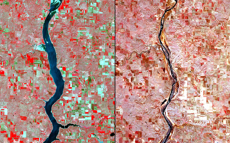
January 10, 1988 / April 6, 2008
Dam impact, Paraguay
The Yacyretá-Apipé dam is a hydroelectric plant on the Yacyretá-Apipé falls of the Paraná River, between Argentina and Paraguay. Its construction displaced human populations and affected both aquatic and terrestrial wildlife habitats. The availability of reservoir water for irrigation has led to the establishment of extensive, industrial agriculture, which has increased urban growth and pressure on watercourses. The dam also causes problems for the Iberá Wetlands, one of the most important wetlands in South America, whose delicate equilibrium allows a high level of biodiversity as well as water for human consumption. The 2008 image shows the Yacyretá reservoir and the increased number of cultivated parcels near the reservoir’s edge.
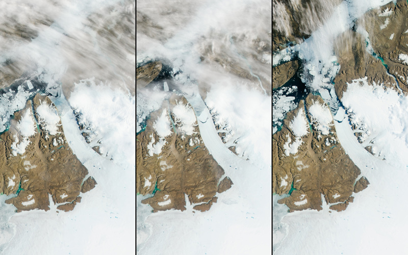
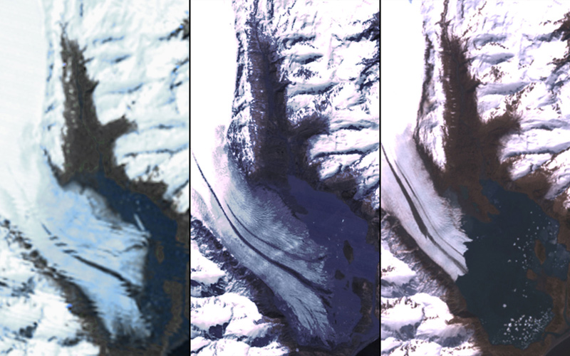
July 16, 2012 at 10:25 UTC / July 16, 2012 at 12:00 UTC / July 17, 2012
Glacier calving, Greenland
The Petermann Glacier grinds and slides toward the sea along the northwestern coast of Greenland, ending in a giant floating tongue of ice. An iceberg about twice the size of Manhattan broke free of that tongue in July, 2012. Two years prior, Petermann calved an iceberg twice as big as this one. A glacier is essentially a slow-moving river of ice. When a glacier protrudes into the ocean, as the Petermann Glacier does, ice occasionally breaks off the end, creating new icebergs. The frequency depends on how fast the glacier grows because of new snow, how quickly it flows into the ocean, and how fast it melts. Petermann Glacier’s floating ice tongue is the largest in the Northern Hemisphere.
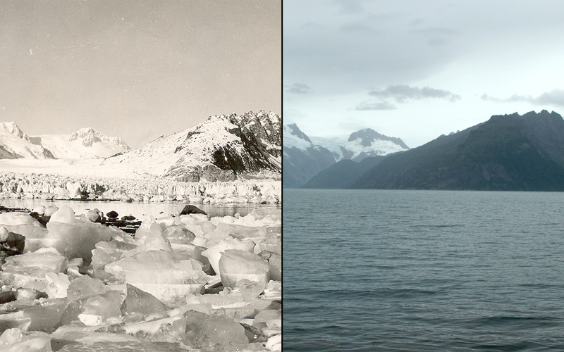
1940 / August 4, 2005
Northwestern Glacier melt, Alaska
Northwestern Glacier. With few exceptions, glaciers around the world have retreated at unprecedented rates over the last century.
February 1, 1973 / September 28, 2005
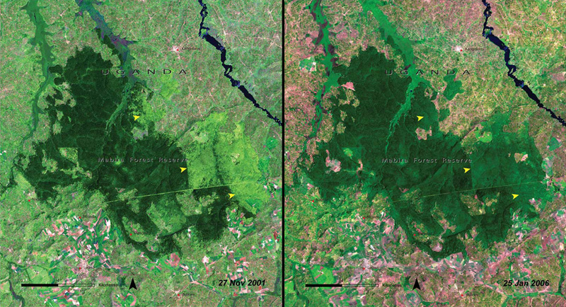
Deforestation, Uganda
Mount Elgon is an extinct volcano that supports a variety of plant and animal life. In addition, some of Uganda’s densest human population areas are found along the borders of Mount Elgon National Park. Most of these people rely on pastoralism and subsistence agriculture, and the growing population creates a strong demand for farmland and grazing land. In an effort to manage the resources, local people were resettled in 1983 in an area previously managed as forest (yellow arrows), which proved very problematic. Since the mid-1980s, management of this area has taken a more community-based approach, but striking a balance between protecting the mountain’s natural resources and meeting the needs of the local communities is ever more challenging.

February 4, 1973 / December 7, 2008
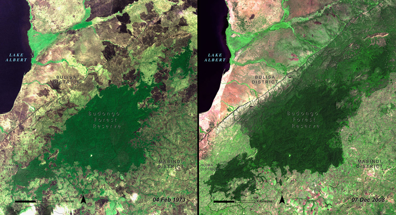
Reforestation, Uganda
The Budongo Forest Reserve, Uganda, which has seen woody cover both increase and decrease. In the northern part of the reserve, the installation of a park entry gate and increased policing have reduced the incidence of local communities burning the trees. In other areas where there has been continuous burning, tree species have changed from those that are particularly vulnerable to fire to those that are more fire-resistant. Fire scars can be seen in the 1973 image; there are almost no fire scars seen in 2008.
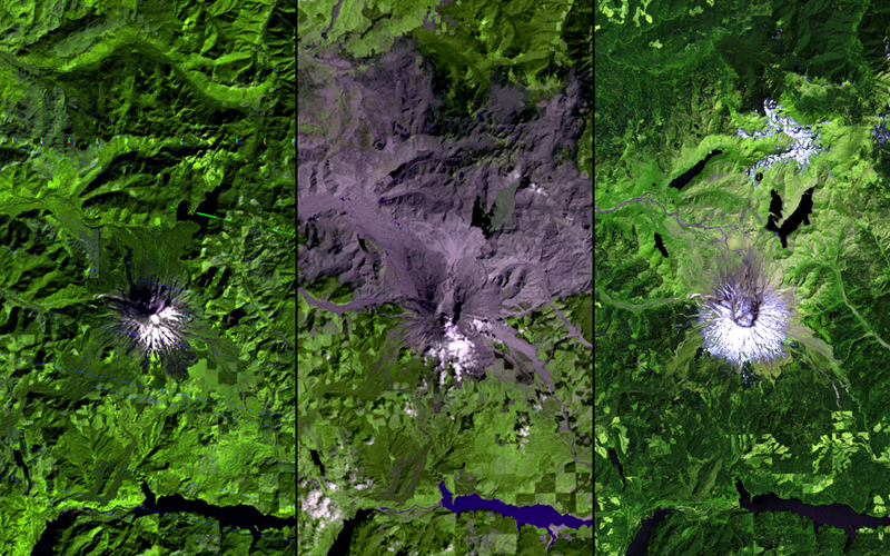
October 17, 1974 / August 19, 1980 / July 30, 2011
Volcano eruption, Washington
Mount St. Helens in southeastern Washington state suffered a massive eruption in 1980. It destroyed homes, river channels and heavy forests—the most economically destructive such event in U.S. history. The left-hand image shows the region before the eruption, with snow on the southern slopes and heavy forests surrounding the volcano. In the center picture, lava and ash have engulfed much of the surrounding landscape. As seen in the right-hand image, the region largely recovered by 2011. Forests and grasslands have regrown and the lakes and rivers have been recharged. A small section on the northern slope of the volcano is still dominated by ash, preventing extensive vegetation growth.